
Map of the gorge
Location
Time: 5:10h
Ascent: 3:25h
Descent: 1:45h
Difficulty
Elevation difference: 650m
Discovered for rokling.cz by Průzkumníklára.
Trail description
Shortly before Ostružná village turn right and after about 700m you will come to a crossroads next to a sewage treatment plant, here you can park. From the sewage treatment plant, continue for about 1.1km and after passing a chapel, turn left past a cottage by a weir. After the cottage you can enter the stream bed and follow it to the source of the Klepáčský brook.
Watch out for fallen trees and logs along the way, especially after rain or storms. The Klepáčský brook winds through a mixed forest of mostly beech, spruce and maple trees. The whole area is included in the Jeseníky Protected Landscape Area, and the forest is therefore completely “natural” and without any modifications. Please keep this in mind and be respectful of nature!
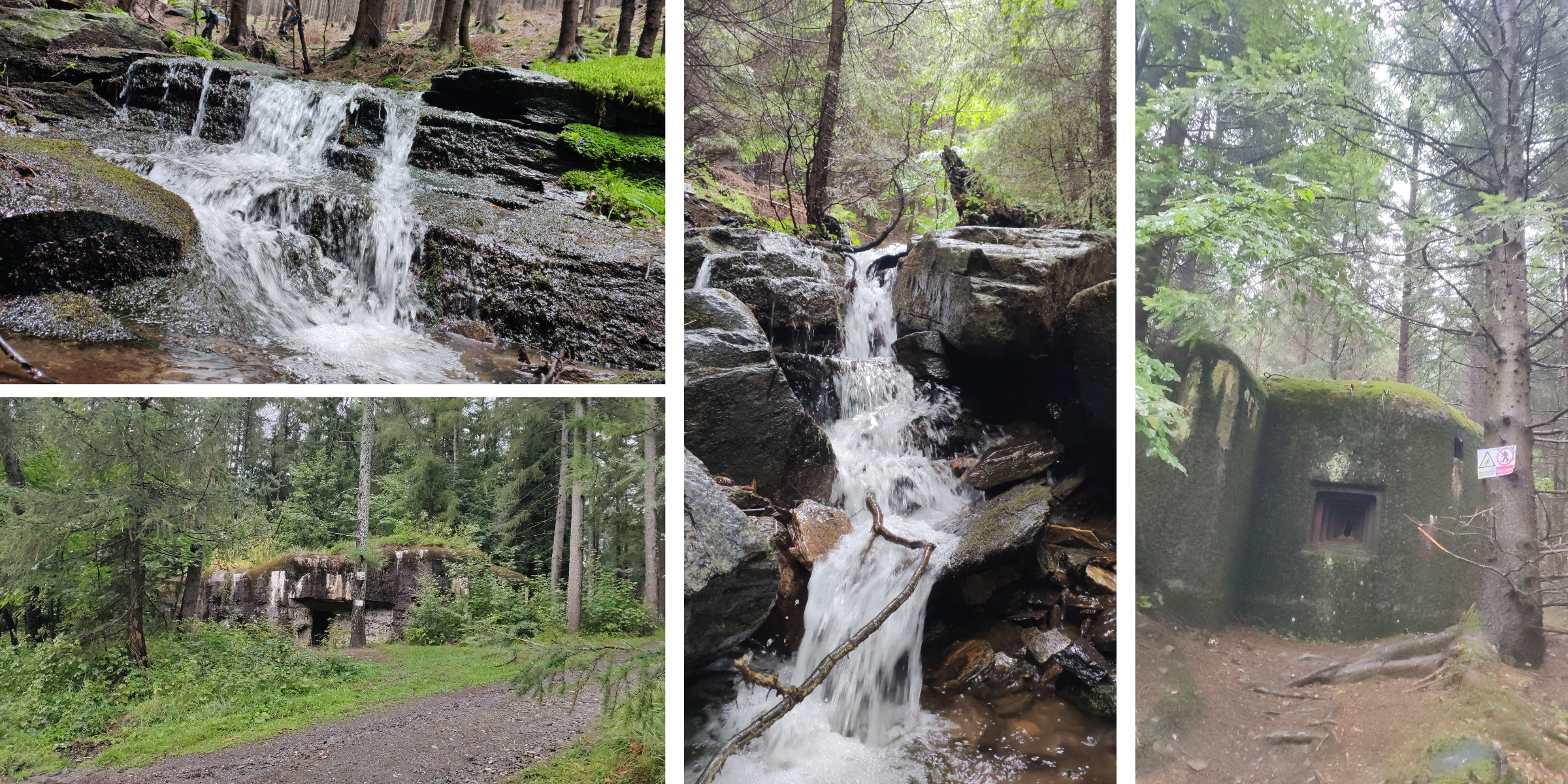
From the beginning of the Klepáčský brook you can notice several bunkers, the so-called “diggers” or infantry huts. Near the house by the weir you passed there is a Museum of Czechoslovak Fortification Branná, where you will be guided through the bunkers and introduced to their purpose. The bunkers date back to the period of general mobilization, 1938.
The higher up the stream you go, the more rocks and boulders start to appear, over which the water has found its way and carved interesting pictures. At first the channel is wide, but gradually it narrows and becomes more and more wild. Occasionally, meanders form as the water finds its way through the hard bedrock. The boulders are covered with moss and ferns grow everywhere, giving the whole place a fairy-tale feel. The water jumps over the rocks and washes out the surrounding banks.
The Jeseníky Mountains are brimming with water, water springs everywhere and you will constantly meet tiny streams flowing into the Klepáčský brook. If you are attentive, you will come across many haylofts or feeders for the local wildlife.
You will also come across a dam that was built here to regulate the flow. There are about three other similar dams upstream, but smaller.
At the fork in the streams, turn left (Deer Creek branches off to the right). You can see the ancient bridge and the many waterfalls that make up Klepáčský brook. Higher and higher upstream, the creek gets really steep and wild and the path becomes more challenging.
In the uppermost part of Klepac Creek, the bedrock is made up of gneiss and marble, and the beautiful grey and white streaks are clearly visible on the rock that the water rushes over. Waterfalls and interesting water formations increase with altitude. Be careful though, the rocks are really slippery and the trail can be very dangerous after rain.
Just below the spring the stream branches off, at the last turn continue left to the waterfalls on the Klepáčský brook, then return the same way and continue on to the waterfall Ve Stržích and on to the source of the Klepáčský brook. The largest of the waterfalls on Klepáčský brook is 4m high. The others are about 3 m high. They are definitely worth a look. Really attentive observers can also spot a fox, we saw three on our trip! Don’t go near them, they can carry rabies.
From the source of the Klepáčský brook you can go to Keprník mountain, but in the national nature reserve Šerák – Keprník it is forbidden to walk outside the marked hiking trails, so you have to take a slight detour to Keprník. To descend, return a short distance downstream before you hit the forest path and follow it for about 1.5km before you join the red hiking trail. Disconnect from the red hiking trail at the “Nad Dobrou Vodou” fork and follow the blue trail to the finish. A short distance from the crossroads there is a nice natural well called Dobrá voda, where you can refresh yourself with very tasty water. Follow the blue trail until you reach the crossroads “Nad Splavem”, where you turn right. Around the blue hiking trail you can come across 12 small bunkers and one infantry cabin, definitely worth a look.
Recommendation
The trail is not really suitable for smaller children, it is really challenging at the top near the spring and you often have to climb over fallen logs and rocks where small children would not even take such a big step.
It’s also a good idea to bring a change of clothes and shoes, as the rocks are very slippery and it’s easy to slip into the water.
The trail is long and challenging, it doesn’t hurt to pack some snacks.